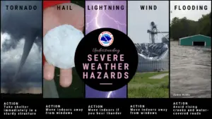
“When thunder roars, go indoors,” advises Emergency Management Ontario as severe weather looms over London.
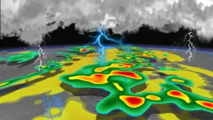
Environment Canada has issued a severe thunderstorm watch for the area. Residents are warned that hail could reach the size of a toonie, with damaging winds gusting up to 70 km/h expected.
The forecast predicts thunderstorms will develop early Tuesday morning, bringing with them 5 to 10 millimeters of rain. The daytime high is set at 23 degrees Celsius, but it may feel like 28.
Yosef Mengesha, a local meteorologist, stated, “So far we haven’t seen any reports, but that size of hail could damage property.” This follows a week where parts of the U.S. experienced softball-sized hail and over 700 reports of quarter-sized hail were logged by the U.S. Storm Prediction Center.
In southern Wisconsin, a trained spotter reported a hailstone measuring around 10 cm (4 inches) in diameter—highlighting the severity of recent storms.
The situation escalated further with Canada’s first tornado warning of the year issued due to this storm system. Emergency Management Ontario urges everyone to take cover if threatening weather approaches.
As residents prepare for potential impacts, they are reminded that conditions can change rapidly. A 40 percent chance of showers is forecasted for Tuesday morning, increasing to 60 percent on Wednesday with highs around 18 degrees Celsius.
While London braces for what may come, many are reflecting on how this unusual weather pattern affects their daily lives. With repeated rounds of severe thunderstorms hitting northern and central U.S., the ripple effects are felt across the border.
The community is on high alert as they await updates from local authorities and meteorologists regarding this unpredictable weather event. Details remain unconfirmed about how severe the impact will be.