Introduction
Weather radar maps have become an essential tool for meteorologists and the general public alike. These maps provide real-time information about weather conditions, including precipitation, storm systems, and severe weather alerts. Understanding how to interpret these maps is crucial, especially for those living in areas prone to extreme weather events. As climate change intensifies weather patterns, the ability to accurately track storms and their impacts is more relevant than ever.
How Weather Radar Works
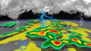
Weather radar systems operate by emitting radio waves that bounce off precipitation particles, enabling meteorologists to determine the location, intensity, and type of precipitation in a given area. The information gathered is displayed on radar maps, which can be accessed by the public via websites and apps. Different colors on the maps indicate varying levels of precipitation intensity, with bright reds and yellows generally signifying heavy downpours or storms.
Current Events and Developments
Recent advancements in technology have significantly improved the accuracy and detail of weather radar maps. For example, the new dual-polarization radar technology allows for a better distinction between rain, snow, and hail, enhancing forecast reliability. As of October 2023, many regions across Canada have already experienced a series of intense storms, prompting meteorologists to rely heavily on radar maps for timely updates. In Alberta, severe thunderstorms swept through in late September, leading to flash floods in several communities. Authorities used radar map data to issue timely advisories, helping to mitigate damage and protect residents.
Significance for Daily Life
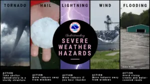
Weather radar maps are not just vital for meteorologists; they have practical applications for everyday life. Farmers depend on accurate weather data to make decisions regarding planting and harvesting, while outdoor event planners, travelers, and emergency services use radar maps to prepare for potential weather disruptions. Furthermore, public access to radar maps empowers citizens to take proactive measures when severe weather threatens their area.
Conclusion
The role of weather radar maps in our understanding of climate and weather patterns cannot be understated. As we face an era of unpredictable weather, having access to real-time data is captivating and critical for safety and planning. With ongoing technological advancements, the future of weather radar maps promises even greater accuracy and utility for everyone. Keeping an eye on the radar may just keep you one step ahead of the storm.